Tsho Rolpa Lake
Tsho Rolpa Lake
Glacial lake at 4,580 m altitude in the Rolwaling valley, Tsho Rolpa is reached by a 7 to 10-day trek from Dolakha district.
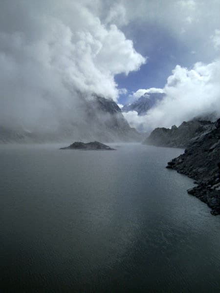
Tsho Rolpa Lake stretches at 4,580 metres altitude in the Rolwaling valley, near the Tibetan border. This glacial lake, formed by the melting of the Trakarding Glacier, is now six times larger than in 1950 and ranks among Nepal's most closely monitored water bodies due to the risk of glacial outburst flooding (GLOF).
Why visit Tsho Rolpa Lake
Tsho Rolpa offers a trekking experience far removed from the classic circuits of Annapurna or Khumbu. The Rolwaling valley, long closed to outsiders, retains a strong Tibetan identity and moderate tourist traffic. The lake itself illustrates the rapid transformations of the Himalayas in the face of glacial retreat: its volume, surface area and technical monitoring make it as much a hiking destination as a emblematic site of climate change.
Beyond the lake, the route crosses Sherpa and Tamang villages where high-altitude agriculture, yaks and Tibetan Buddhism still govern daily life.
History and challenges of the glacial lake
Tsho Rolpa was formed by the accumulation of meltwater from the Trakarding Glacier, behind a natural moraine. Since 1990, this fragile barrier has threatened to give way, putting approximately 6,000 villagers living along the Tama Kosi river downstream at risk. In 1997, surveys estimated that the lake contained between 90 and 100 million cubic metres of water.
An early warning system was installed in 1990 to prevent a sudden breach. After becoming defective in 2012, it was replaced following the 2015 earthquake, which destabilised moraines throughout the region. Today, NGOs and government programmes continue stabilisation work and water level monitoring.
What you will see on site
- The glacial lake: an elongated expanse framed by moraines, fed by the Trakarding Glacier and drained towards the Tama Kosi and Rolwaling valleys.
- Mount Gaurishankar (7,134 m): a sacred peak for both Hindus and Buddhists, visible over much of the trek.
- Villages of the Rolwaling valley: Beding and Na, inhabited by Sherpa communities, as well as Tamang hamlets lower down. You will find gompas, prayer wheels and terraced fields.
- Rhododendron forests in the lower part of the route, particularly spectacular in spring.
How to get there
The starting point is in Dolakha district, 7 to 8 hours by road from Kathmandu. A private car or shared 4x4 is the most reliable option, as local buses are slow and infrequent on the final stretch.
From Dolakha, the classic trek follows the Shingati – Jagat – Daldung – Beding – Na route. Beyond Na, a wooden bridge crosses the left bank of the Rolwaling river, then the route climbs through high-altitude meadows to the lake. Allow 7 to 10 days return depending on your acclimatisation pace.
When to go
The best period is in spring, between March and April, when the rhododendron forests are in full bloom and the weather remains stable. Autumn (October-November) also offers good visibility over the peaks, though without the colour of the blooms. Winter is very cold at 4,580 metres and the monsoon (June-September) makes trails slippery and views often obscured.
Practical information
- Maximum altitude: 4,580 m. Progressive acclimatisation is essential to limit the risk of acute mountain sickness.
- Level: challenging trek but with no technical sections, accessible to trained walkers.
- Permits: the Rolwaling zone requires a specific trekking permit (Gaurishankar Conservation Area). Using a local agency is recommended.
- Accommodation: basic lodges in villages, bring a warm sleeping bag.
- Equipment: warm technical clothing, good trekking shoes, glacier glasses, high-altitude first aid kit.
What to see in the region
Before or after the trek, several sites complement a circuit in central Nepal:
- The Kalinchowk temple, also in Dolakha district, accessible from Charikot.
- The Boudhanath stupa, a major spiritual stop in the Kathmandu valley.
- The Ganden monastery to deepen your immersion in Tibetan Buddhism.
Frequently asked questions
Frequently asked questions
The trek is classified as difficult due to the altitude (4,580 m) and duration (7 to 10 days), but it has no technical sections. Good physical fitness and progressive acclimatisation are essential.
The lake itself is safe for visitors. The risk concerns villages downstream, exposed to potential glacial outburst flooding (GLOF). An alert system and stabilisation work are in place.
Yes, access to the Gaurishankar conservation zone requires a permit and a guide is strongly recommended due to the isolation, altitude and limited trail signage.
Allow 7 to 8 hours by road to Dolakha, then 7 to 10 days of walking return to reach the lake and descend, depending on your chosen acclimatisation pace.
Planning your trip to Nepal
Tsho Rolpa fits into a broader itinerary combining off-the-beaten-track trekking, the Kathmandu valley and Tibetan culture. To build a tailor-made circuit, consult our Nepal trips.
Interested in this visit?
We can include it in your personalised itinerary.